WWII: Maginot Line | Normandy | V-Weapon Sites | Arnhem
Further afield: Crete
| Home Tracing Military Ancestors Travel Advice CWGC Cemeteries Iron Harvest News Book Reviews Glossary Links Contact Me Artois:
 
|
Locations 8 and 9 – Vimy Ridge Memorial Park
Directions – From The French National Cemetery, cross over the D937 into La Targette and, on reaching the centre of the village, follow the signs to the Vimy Ridge Memorial Park. They will lead you across the motorway and into the car park of the Interpretative Centre on your right. Practical Information – Like Notre Dame de Lorette, the Vimy Ridge Memorial Park contains a number of sights for the visitor and allow a good two hours to see everything. The site can get very busy, particularly on Saturdays and summer afternoons although a new car park at the top of the hill near the memorial has alleviated the situation somewhat. I have arranged the sites below in order from the bottom of the ridge to the top but it may be an idea to enquire in the Interpretative Centre when the next Grange Subway tour is, so you can plan your visit around it. Also a word of warning – there is still a lot of unexploded ordnance amongst the woods and in the fields – the danger signs instructing visitors to keep to the paths are there for good reason! Vimy Ridge Interpretative Centre – for full details see the museums page. Grange Subway – Next to the Interpretative Centre, behind the flagpole, is the entrance to one of the subway systems that played such a key part in the successful capture of the ridge in April 1917. Tours of the tunnels are conducted by Canadian student guides and last about half an hour. Only part of the system is accessible but sights on the tour include the Signals Office, Sleeping Quarters, Commander’s Office, First Aid Post and Dressing Station and Pump Room. The student guides are very well informed and welcome questions to test their knowledge.
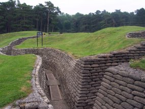
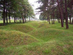
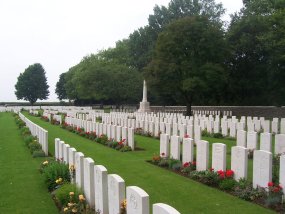
Preserved Trenches and Mine Craters – Next to the subway entrance are a number of preserved trenches and craters – the result of the constant mining activity, which was such a feature of the fighting at Vimy Ridge. The trenches mark the Canadian and German outpost lines at the start of the April 9th 1917 offensive. They would have been fairly lightly defended, the bulk of the infantry being kept back in the second and third lines, but they do demonstrate the close proximity of the protagonists. In such a compacted battlefield, the craters left by mine explosions assumed immense tactical significance and were given names. Thus, the two craters either side of the path linking the Canadian and German front lines are known as the “Grange” group. The crater beyond to the right is “Tidsa” and in the trees to your left front are the “Duffield” group of craters. Canadian Cemetery No2 – For this cemetery, turn right as you leave the Interpretative Centre car park and take the next left as you head up to the National Memorial. This cemetery was begun after the 9th April attack on Vimy Ridge and was also used as a concentration cemetery after the war. There are just under 3,000 graves here, of whom one-third are Canadian and two-thirds British.
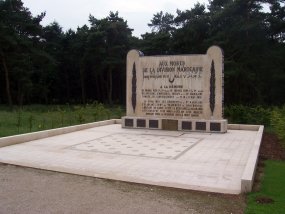
Moroccan Division Memorial – Opposite the Canadian National Memorial is this one dedicated to the incredible achievement of the Moroccan Division who managed to get as far as Point 145 in the Second Battle of Artois in May 1915.
Canadian National Memorial – The centrepiece of the Memorial Park, the National Memorial dominates the skyline for miles around and sits on the highest point of the ridge – Point 145. Along with the Menin Gate at Ypres and the Thiepval Memoral on the Somme, it is one of the most iconic Commonwealth memorials on the Western Front and a massive symbol of the central role that Vimy Ridge played in the story of Canadian nationhood.
It was designed by the sculptor, Walter Seymour Allward, and uses 12,000 tons of concrete for the foundations and 6,000 tons of Dalmation stone for the figures and two pylons, which represent Canada and France. On its base are etched the names of all 11,285 Canadian soldiers who were killed in France during the First World War and have no known grave. Opened in 1936 by King Edward VIII in his only overseas engagement, the memorial recently underwent a major renovation to repair cracks and faults caused by decades of weathering. Historical Notes – On the morning of 9th April 1917, Princess Patricia’s Canadian Light Infantry (PPCLI), left their forward positions where the preserved trenches now stand in the lower part of the memorial park, and swept forward to their first objective – a trench junction 600 yards to the north-east. Such was the scale of the preparatory bombardment that very little resistance was encountered from the German defenders and the PPCLI were soon pressing onto their second and final objective – La Folie Wood a further 500 yards distant. Here resistance became stiffer and the battalion had to bomb the German defenders out of their dug-outs and trenches in a ferocious combat. Despite taking all their objectives by 10:30am, however, the PPCLI and the 42nd Battalion to their left, began to take serious casualties from snipers on Point 145 which had still not been taken and which left the flanks of these two battalions dangerously exposed. Indeed, the PPCLI suffered only 50 casualties in the assault but a further 160 in the hours 24 hours following it. The 11th Brigade of 4th Canadian Division had the responsibility of capturing Point 145 – the highest point of the ridge (where the memorial now stands), but German defences here proved too strong for it to be taken on the 9th April. In fact the Germans had riddled the position with tunnels, machine-guns and dugouts, turning it into a veritable fortress. The fire from here seriously derailed the 4th Division attack and it wasn’t until midday on 10th using considerable reinforcements from the divisional reserve, that Point 145 was at last in Allied hands. Beyond, was a scene that no Allied soldier had glimpsed since May 1915. Eyewitness Account – One Canadian soldier said of the view from the top of the ridge: "A wide expanse of open country – green fields, woods and villages untouched by war – stretched to the skyline for miles on all sides. On the easterly horizon the smoking factory chimneys of Douai were plainly visible and some men announced that through glasses they were able to observe the clock dial on a high tower... A fugitive horseman, apparently pursued by bullets, was zig-zagging across the plain, clinging with hands and knees to the neck and body of his steed; enemy guns were standing on the open plain of Willerval, deserted by their crews." Extract taken from Nigel Cave’s Vimy Ridge, part of the Battleground Europe series published by Leo Cooper, 1997.
|
||||||||||||

