WWII: Maginot Line | Normandy | V-Weapon Sites | Arnhem
Further afield: Crete
| Home Tracing Military Ancestors Travel Advice CWGC Cemeteries Iron Harvest News Book Reviews Glossary Links Contact Me Normandy Landings:
 
|
The British and Canadian Seaborne Landing Zones – A Photographic Overview
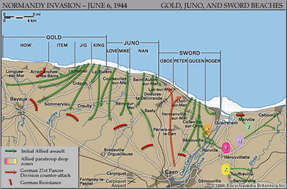
Overview Introduction – It is a widely held misconception that on D-Day the Allies landed uniformly along all the beaches they had code-named, from UTAH in the west to SWORD in the east. Nothing could be further from the truth. Although the scale of the assault was unlike anything that had gone before, German defences were sufficiently strong and good exits from the beach few and far between enough, to force the Allies to concentrate their landings on a handful of beach sub-sectors. Thus, whilst some stretches of the coastline witnessed bitter fighting lasting well into the afternoon, others were not attacked directly at all. This is good news, of course, for the battlefield visitor as it means that attention can be focused on a reasonable number of key locations, which are central to explaining how the story of D-Day unfolded. To illustrate this, the map and chart below provide details of all the British and Canadian landing beaches including sub-sectors moving from west to east, units involved and supporting naval forces offshore which should prove helpful as you navigate the area.
British and Canadian Landing Beaches - D-Day For a full explanation of how armies were organised in the Second World War, see the glossary. In addition, I have included a couple of locations, namely the Longues-sur-Mer Battery and the radar site at Douvres-la-Délivrande, which were inland of the beaches but were assaulted in the subsequent days after the landings to help secure the lodgement area. As will also be explained, although GOLD and SWORD beaches are mentioned in the overview, because of the scandalous lack of general interest shown these two British beaches whenever the events of D-Day are recounted on TV, in films or the media, I have decided to devote a warwalk to each at a later date. The fact that the landings here did not end in a debacle such as happened at OMAHA, should not detract from the extraordinary ingenuity of the British Command and heroism of its soldiers in successfully breaching the Atlantic Wall at these points. Practical Information – This tour can be completed, at a stretch, during the course of one day although this will lead to an element of "clock-watching". In the author's opinion, taking the tour over two days is much more comfortable with ample time to take in the surroundings and visit some of the excellent museums en route. For those who like to eat in the field, a hearty packed lunch should be brought along, although the restaurants in some of the seaside towns in the Canadian sector, including Courseulles-sur-Mer and St-Aubin-sur-Mer are particularly recommended. Crowds at the locations themselves should not be too much of an issue on this tour, although it should be remembered that the beaches are a major summer holiday destination and traffic can be heavy in the coastal towns during this period. |
||||||